FMB Sketch Online – The Field Measurement Book (FMB) drawing is a collection of map information held in bulk at each Tahsildar office by the government. The individual survey number drawings in FMBs are kept at a 1:1000 or 1:2000 scale. There are several different subdivisions for every survey number. An owner of real estate is the owner of each subdivision number. FMB shows the exact measurements of the land. Therefore, an FMB sketch is utilised to confirm the land dimensions and property borders in a real estate acquisition process.
To perform computations or complete other activities, engineers and other professionals frequently use the FMB to determine the exact dimensions of a field. To ensure that their measurements are accurate, surveyors frequently consult this book.
The FMB could benefit anybody who needs to measure a field precisely. It can aid in ensuring that measurements are conducted correctly, and the outcomes are trustworthy.
Features and Benefits of FMB Sketch Online
- Enhanced Accessibility and Convenience: FMB Sketch Online provides a centralised repository for field measurement sketches, enabling users to access detailed land information conveniently from their homes or offices.
- Time and Cost Savings: The online platform significantly reduces the associated costs of traditional land record retrieval processes. By eliminating expenses related to transportation, document retrieval, and photocopying, FMB Sketch Online simplifies the process of acquiring property information.
- Empowerment for Property Owners and Developers: Property owners benefit from the accurate and up-to-date property information FMB Sketch Online provides. For land developers, the platform is a valuable tool for making informed decisions regarding site planning and land utilisation strategies.
- Promotion of Transparency and Accountability: FMB Sketch Online contributes to a culture of transparency by making field measurement sketches publicly accessible. This openness empowers citizens to scrutinise property information, reducing opportunities for corruption and malpractices in land administration.
- Strengthens Public Trust: The enhanced transparency provided by FMB Sketch Online fosters confidence in the fairness and integrity of land records management. Government agencies benefit from the platform’s centralised features, simplifying operations and enhancing overall accountability in land administration.
- Streamlining Land-Related Processes: FMB Sketch Online plays a pivotal role in various land-related processes, including property tax assessment, land dispute resolution, and land development planning. The platform ensures fair and equitable property tax assessment by providing accurate land dimensions.
Components of FMB
The following are the various components of FMB:
- G-line
- F-line
- Subdivision lines
- Ladder
- Extension lines
- Neighboring field survey numbers
These components are further discussed in detail:
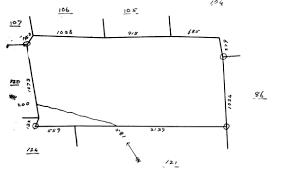
G-line
G-line outlines the making of the entire sketch. It is an imaginary line that converts the sketch into various sizes of triangles to fix the boundary lines and the various points in the sketch. Errors in G-line will affect all the pertinent calculations.
F-line
F-line signifies the actual field boundaries in the outer lines of the sketch. Its points are fixed with reference to its offset distance from the G-line.
Subdivision Lines
Subdivision lines demarcate a small portion of land within a survey number. A sub-divisional extent of a polygon is directly correlated to the extent found for the particular subdivision. The subdivision lines are generally defined through a ladder, or the likes of it; except for the graphical representation in FMB.
Ladder
The field line points are defined with reference to an offset distance from the G-line. The offset distance may deviate to the left or right side of the G-line. This left or right angle deviation is highlighted by the ladder. Converting the ladder details into electronic data can produce the outline of the FMB sketch.
Extension Lines
Each survey number field forms a crucial part of the village map, and as a result of it, other fields surround each sketch. The precise direction wherein the subject field joins the neighboring field is depicted on the FMB as an extension line.
Neighbouring Field Survey Numbers
The other fields surround each of the survey sketches. These surrounding field numbers are marked around each FMB. This facilitates the conversion of FMB’s into D-sketches, and so on and so forth.
How to Get FMB Sketch?
- Head to the Taluk office in the relevant area to obtain a copy of the FMB sketch for the desired land.
- Approach the Tahsildar with a formal request for the FMB sketch. Fill out a request form specifying the survey number relevant to the land.
- Complete the form, attest it with your signature, and attach all necessary documents. Submit the entire package to the relevant authority.
- The Tahsildar reviews the requests, either approving or rejecting them. In case of rejection, an appeal can be made to the District Collector.
- Pay the required fee and obtain a receipt for future reference.
- Upon approval, receive the FMB sketch copy of the land, complete with a unique reference number. This systematic process ensures a smooth and regulated acquisition of FMB sketches.
FMB Sketch Types: Field Sketch Types
- Profile Sketches: Profile sketches illustrate the ground profile along a specific line, offering insights into the topographical features and elevations present in the surveyed area.
- Plan Drawings: Plan drawings provide a comprehensive layout of an area, detailing the placement of buildings, roads, and various features. They offer a visual representation of the spatial arrangement and organisation within the surveyed land.
- Elevation Sketches: Elevation sketches depict changes in ground elevation along a designated line, making them particularly useful for projects like proposed pipeline routes. These sketches offer a detailed understanding of the terrain’s vertical variations.
FAQs
How to use FMB?
Surveyors and engineers use FMB to record precise measurements and create accurate site maps. It helps verify land dimensions and property borders and is essential in real estate acquisition.
What is FMB in the Land Survey?
In land surveying, FMB, or Field Measurement Book, is a compilation of map data stored in volumes at the Tahsildar office. It records precise measurements at scales of 1:1000 or 1:2000, providing essential information for surveyors and engineers.
Practice area's of B K Goyal & Co LLP
Income Tax Return Filing | Income Tax Appeal | Income Tax Notice | GST Registration | GST Return Filing | FSSAI Registration | Company Registration | Company Audit | Company Annual Compliance | Income Tax Audit | Nidhi Company Registration| LLP Registration | Accounting in India | NGO Registration | NGO Audit | ESG | BRSR | Private Security Agency | Udyam Registration | Trademark Registration | Copyright Registration | Patent Registration | Import Export Code | Forensic Accounting and Fraud Detection | Section 8 Company | Foreign Company | 80G and 12A Certificate | FCRA Registration |DGGI Cases | Scrutiny Cases | Income Escapement Cases | Search & Seizure | CIT Appeal | ITAT Appeal | Auditors | Internal Audit | Financial Audit | Process Audit | IEC Code | CA Certification | Income Tax Penalty Notice u/s 271(1)(c) | Income Tax Notice u/s 142(1) | Income Tax Notice u/s 144 |Income Tax Notice u/s 148 | Income Tax Demand Notice | Psara License | FCRA Online
Company Registration Services in major cities of India
Company Registration in Jaipur | Company Registration in Delhi | Company Registration in Pune | Company Registration in Hyderabad | Company Registration in Bangalore | Company Registration in Chennai | Company Registration in Kolkata | Company Registration in Mumbai | Company Registration in India | Company Registration in Gurgaon | Company Registration in Noida | Company Registration in lucknow
Complete CA Services
RERA Services
Most read resources
tnreginet |rajssp | jharsewa | picme | pmkisan | webland | bonafide certificate | rent agreement format | tax audit applicability | 7/12 online maharasthra | kerala psc registration | antyodaya saral portal | appointment letter format | 115bac | section 41 of income tax act | GST Search Taxpayer | 194h | section 185 of companies act 2013 | caro 2020 | Challan 280 | itr intimation password | internal audit applicability | preliminiary expenses | mAadhar | e shram card | 194r | ec tamilnadu | 194a of income tax act | 80ddb | aaple sarkar portal | epf activation | scrap business | brsr | section 135 of companies act 2013 | depreciation on computer | section 186 of companies act 2013 | 80ttb | section 115bab | section 115ba | section 148 of income tax act | 80dd | 44ae of Income tax act | west bengal land registration | 194o of income tax act | 270a of income tax act | 80ccc | traces portal | 92e of income tax act | 142(1) of Income Tax Act | 80c of Income Tax Act | Directorate general of GST Intelligence | form 16 | section 164 of companies act | section 194a | section 138 of companies act 2013 | section 133 of companies act 2013 | rtps | patta chitta